Maps Of Afghanistan
Location and Size of Afghanistan
Afghanistan is a country in the center of Asia. Many people call this area Central Asia or South Asia. It has been a key spot for travel and trade for thousands of years. Its central location connects many regions. Afghanistan is around 652,860 square kilometers in size. This makes it medium-sized when compared to its neighbors. The capital city is Kabul, which is in the eastern part of the country. Afghanistan has many mountains, valleys, and dry lands that give it a very unique look.
Geography of Afghanistan
The geography of Afghanistan is very rugged. Much of the land is high and rocky. Tall mountains span the country, while small villages nestle in the hills. Afghanistan also has deserts where the soil is dry and sandy. These deserts get very hot in the summer and can be very cold at night. In some places, there are wide green valleys where people farm and grow food. The weather changes a lot from place to place. Mountain areas are cool and snowy, while desert areas are hot and dry. Spring brings colorful flowers, and winter brings heavy snow in the high parts of the country.
Rivers and mountains on maps of Afghanistan
People know Afghanistan for its tall and strong mountains. The most famous mountain range is the Hindu Kush. These mountains spread across much of the country and shape the way people live. The highest mountain in Afghanistan is Noshaq. It reaches 7,492 meters and is one of the tallest peaks in the world. Many mountains in Afghanistan remain covered in snow for most of the year.
Afghanistan also has important rivers. The Amu Darya River flows along the northern border and brings water to many farms. The Helmand River is the longest river in the country. It helps people grow crops in the southern areas. Rivers are very important in Afghanistan because many parts of the land do not get enough rain. These rivers support farming, animals, and daily life.
The population of Afghanistan.
Afghanistan has a population of about 42 million people. Many people live in cities like Kabul, Kandahar, Herat, and Mazar-i-Sharif. Cities are busy and full of markets, shops, and homes. But many people also live in small villages in the mountains, deserts, or valleys. These villages often have traditional houses made of mud or stone. Families in rural areas usually farm, take care of animals, or weave carpets. Afghanistan has a young population, which means many children and teenagers live there.
Demographics of Afghanistan.
The people of Afghanistan belong to many different ethnic groups. Some of the major groups are Pashtun, Tajik, Hazara, and Uzbek. Each group has its own history, clothing, music, and traditions. Afghanistan has many languages. The two main languages are Dari and Pashto. Many people can speak more than one language. Islam is the main religion in Afghanistan. Most people celebrate Islamic traditions and holidays. Family is very important in Afghan culture. People respect elders, and families often live close to each other.
Economy of Afghanistan.
Afghanistan’s economy is growing but still faces many challenges. Many people work in farming. Farmers grow crops like wheat, corn, rice, grapes, pomegranates, and nuts. Afghanistan is famous around the world for its delicious dry fruits. The country has minerals like gold and copper. It also has precious stones, such as lapis lazuli, known for its bright blue color. Some people work in making carpets. Afghan carpets are handmade and take many months to finish. They are sold in other countries for good prices.
Trade
Afghanistan trades goods with many countries. It sells fruits, nuts, wool, carpets, and minerals. It buys items such as clothes, machines, medicines, and food products. Since Afghanistan lacks sea access, goods mainly travel by road through nearby countries. Trade is key for Afghanistan’s economy. It helps the country make money and acquire useful goods.
Neighbouring Countries
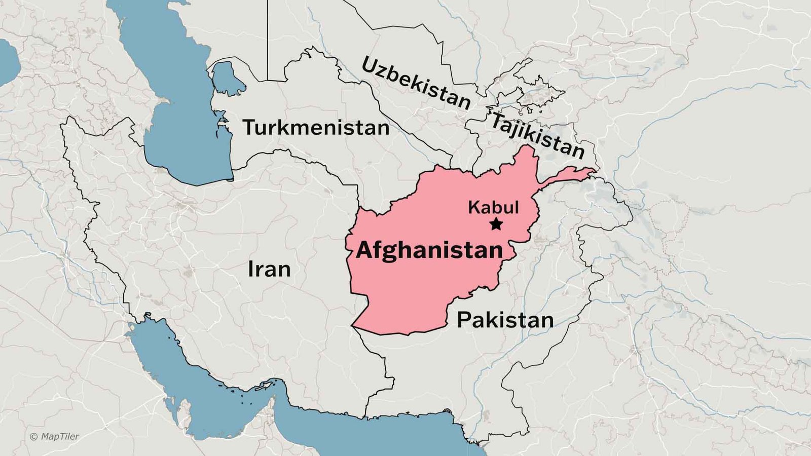
Afghanistan has six neighboring countries. Pakistan is to the east and south. Iran is to the west. Turkmenistan, Uzbekistan, and Tajikistan are to the north. A small border in the northeast touches China. Having many neighbors makes Afghanistan an important connection point in Asia. Goods, ideas, and travelers pass through these borders.
International Relations
Afghanistan works with many countries and international groups to improve health, education, and safety. It is a member of the United Nations. The country receives help from different nations to build roads, schools, and hospitals. Afghanistan aims for peaceful ties with its neighbors. However, it often struggles due to security challenges. Despite these challenges, the country still collaborates globally to promote development and peace.
Tourist Spots
Before conflicts made travel harder, Afghanistan was a popular place for tourists. A popular tourist spot is Herat. It features stunning old buildings and blue-tiled mosques. Another well-known site is Bamiyan. It was home to massive Buddha statues carved into cliffs. The Band-e-Amir lakes are also very special. These lakes are bright blue and surrounded by mountains. The city of Mazar-i-Sharif is known for the Blue Mosque, which glows in the sunlight. Afghanistan’s natural beauty, history, and culture make it a very special country.
Read more aboutThe Cod Wars Explained: Iceland vs United Kingdom
Interesting Facts
• Kabul is one of the highest capital cities in the world.
• Afghanistan is famous for pomegranates, raisins, and dry fruits.
• Artisans have used lapis lazuli from Afghanistan for jewelry for thousands of years.
• People know Afghan carpets for their beautiful patterns.
• The country has many snow-covered mountains.
• The national sport is buzkashi, a horse-riding game.
• The Band-e-Amir lakes are Afghanistan’s first national park.
Watch Afghanistan Geography on YouTube