Australia is both the world’s largest island and the smallest continent. It was first discovered in 1770 by the English explorer Captain James Cook. Geographically, the Tropic of Capricorn runs almost through the centre of the continent, dividing it into two climate zones: the northern half lies in the tropical zone, while the southern half is located in the temperate zone. One of Australia’s most iconic natural features is the Great Barrier Reef—the largest coral reef system in the world.
A significant portion of Australia’s landscape is dominated by the ‘Western Plateau’, which covers two-thirds of the continent. This region receives very little rainfall, leading to the formation of vast deserts. Along the eastern edge lies the Great Dividing Range, a chain of highlands that stretches from Cape York Peninsula in the north down to the island of Tasmania.
The Great Dividing Range is the world’s fifth-longest land-based mountain chain, and that too is entirely contained within a single country. The highest peak in Australia is Mount Kosciuszko, while New Zealand’s tallest mountain is Mount Cook.
The Murray and Darling are notable rivers. Australia is also home to numerous water bodies, including 41 major lakes and over 4,000 smaller ones. Some of the prominent port cities in Australia are Newcastle, Sydney, Melbourne, Adelaide, and Perth. The continent’s temperate grasslands are locally referred to as “Downs”.
- Area: Australia covers an area of approximately 7,692,024 square kilometres, making it the sixth-largest country in the world by total area.
- Population: As of May 2025, Australia’s estimated population is approximately 27.8 million people.
The country’s central region is dominated by deserts, surrounded by grasslands, rainforests, and mountains.
Murray River
The Murray River, Australia’s longest river, stretches 2,508 km, flowing through New South Wales, Victoria, and South Australia before emptying into the Indian Ocean.
Originating in the snowy Australian Alps within Kosciuszko National Park, New South Wales, the Murray begins as a small stream in a mountain called The Pilot. It then enters Lake Hume, a major reservoir, which regulates its flow before the river continues westward.
As it forms the natural border between New South Wales and Victoria, the Murray flows through historic river towns like Yarrawonga, Echuca, Swan Hill, and Mildura, renowned for their paddle steamers and rich heritage.
Along its course, several tributaries strengthen the river—the Ovens River near Wangaratta, Goulburn River at Echuca, Campaspe and Loddon Rivers before Swan Hill, the Murrumbidgee River near Balranald, and finally, the Darling River at Wentworth. The Murray then reaches Lake Alexandrina, flows through the Coorong National Park, and empties into the Great Australian Bight at Murray Mouth.
The river basin sustains millions, including Indigenous communities, diverse plant and animal species, and 40% of Australia’s farms that rely on its water for agriculture.
Map Story: Anomaly in Australian state borders
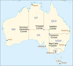
When you look at a map of Australia, the state borders appear completely straight, but they’re not. If you zoom in on the point known as Surveyor Generals Corner, which appears to be a tripoint between Western Australia, the Northern Territory, and South Australia, you’ll notice an anomaly: it’s not actually a true tripoint. The borders are not perfectly aligned and deviate from each other, creating a gap of over 120 meters.
So, how did this happen? Back when the borders were first drawn, surveyors decided to place them along the 129th meridian. To save time, they started from opposite ends, hoping to meet in the middle. Unsurprisingly, the lines didn’t match up, and rather than correcting the mistake, they simply drew a horizontal line to connect the points.
But this isn’t the only straight line with a glitch. The border between Victoria and New South Wales has an even bigger deviation. It was supposed to follow the 141st meridian, but was mistakenly drawn about 3.2 kilometres west of the intended line. When the mistake was discovered, New South Wales moved its border to the correct location. Victoria, however, chose to keep the land it had claimed, leaving us with the oddly mismatched borders at MacCabe Corner that we see today.
Why is 95% of Australia empty?
Watch now: Clicke me
Australia, the largest island on Earth, is almost as large as the contiguous United States. Yet its population density is only about three people per square kilometer, compared to around 41 per square kilometer in the US. This means the US has over 14 times the population of Australia despite their similar sizes.
Australia is rich in natural resources and has plenty of fertile land, yet it is one of the least densely populated countries in the world. But why?
Looking at Australia from space, you’ll see that much of it is covered by deserts. Because of this, the majority of Australians live near the coast. In fact, Australia’s five largest cities are all coastal and together house around two-thirds of the country’s entire population — leaving 95% of Australia practically empty.
Interesting Facts
- Contrary to popular belief, Canberra, not Sydney, is the capital of Australia.
- Unique to Australia are marsupials, animals like kangaroos and koalas, which raise their young in pouches.
- Aboriginals, the first people to settle in Australia, arrived around 50,000 years ago.
- The Great Dividing Range is the world’s fifth-longest land-based mountain chain and that too entirely contained within a single country.