In this post, we will take a look at the Florida County Map. We will understand how many counties Florida has, their names, and their divisions. And the map that is pinned below is free for commercial use.
Most people, when they think of Florida, often picture beaches, theme parks, and palm trees. But Florida is also a state with a rich local identity shaped by its 67 counties. Each county has its own story, culture, and highlights. Whether you’re a resident or planning a visit, here’s a friendly guide to get you familiar with Florida’s counties.
How Many Counties Does Florida Have?
Florida has 67 counties in total. Some are famous worldwide, like Miami-Dade, home to Miami and its beaches. Others are quieter, known more for their natural beauty, historic towns, or close-knit communities.
Read More: US Physical Geography
The Big Names
-
Miami-Dade County: The most populated county, where you’ll find Miami, nightlife, art districts, and a gateway to Latin American culture.
-
Orange County: Home to Orlando and its theme parks, including Walt Disney World and Universal Studios.
-
Hillsborough County: Tampa Bay’s hub with sports, history, and waterfront views.
-
Broward County: Known for Fort Lauderdale, boating canals, and lively beaches.
-
Palm Beach County: Luxury resorts, golf courses, and beautiful coastal towns.
Counties Rich in Nature
-
Monroe County: Famous for the Florida Keys and Key West.
-
Collier County: A gateway to the Everglades and Naples’ quiet beaches.
-
Alachua County: Home to Gainesville and surrounded by springs and forests.
-
Escambia County: Located in the Panhandle, known for Pensacola and its naval aviation history.
Historic and Charming Counties
-
St. Johns County: Where St. Augustine, the nation’s oldest city, brings Spanish colonial history to life.
-
Leon County: Tallahassee, the state capital, is here with political history and a vibrant college-town feel.
-
Marion County: Known as the “Horse Capital of the World” for its thoroughbred farms.
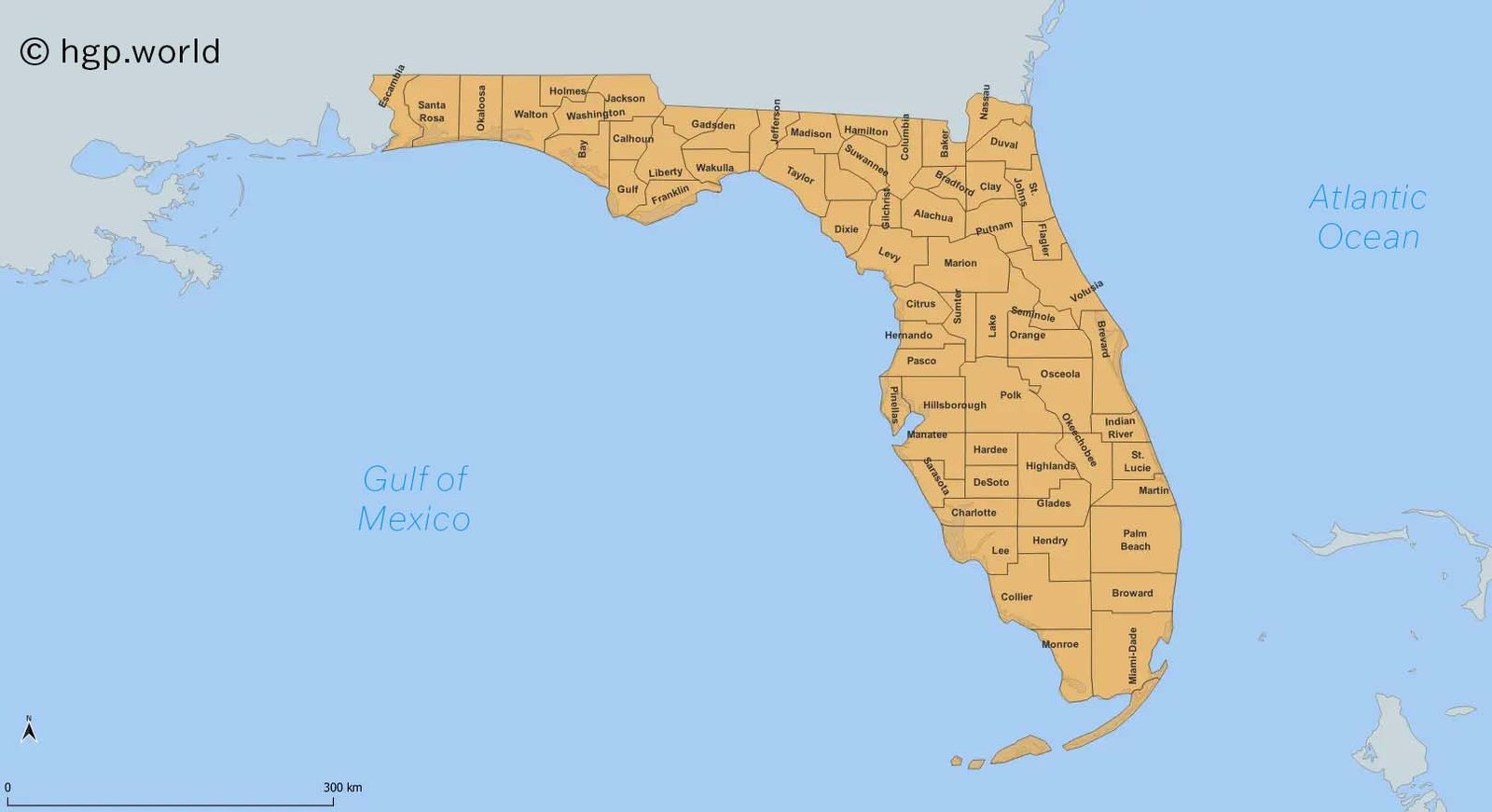
Florida County Map
Florida counties shape local governance, schools, law enforcement, and even the culture you feel when you step into a new area. Driving across the state, you’ll notice how quickly the vibe shifts; one county might feel like a bustling city, while the next feels like a quiet rural retreat.
Florida County Map
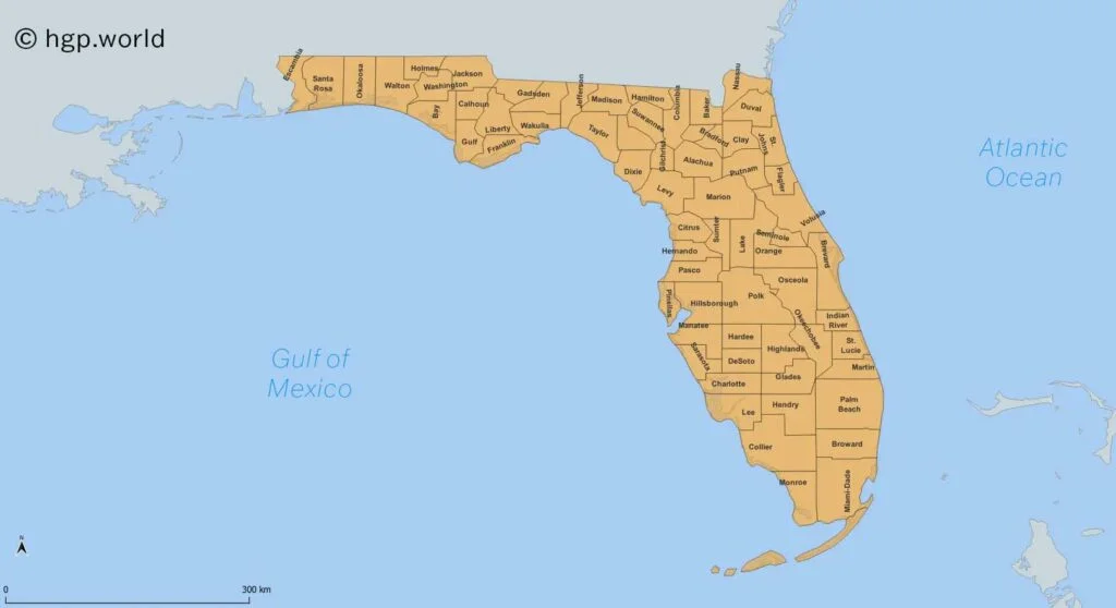
County Map of Florida
Florida County Map District-wise
Northwest District
This district covers the Florida Panhandle and Gulf Coast towns. It’s known for white sandy beaches, small coastal towns, and military history.
Counties:
- Escambia
- Santa Rosa
- Okaloosa
- Walton
- Holmes
- Washington
- Bay
- Jackson
- Calhoun
- Gulf
- Franklin
Northeast District
Stretching along the Atlantic coast and inland areas, this district blends historic cities with natural springs and rivers.
Counties:
- Nassau
- Duval
- Clay
- St. Johns
- Putnam
- Flagler
- Columbia
- Baker
- Union
- Bradford
- Suwannee
- Hamilton
- Madison
- Alachua
- Gilchrist
- Dixie
- Lafayette
- Taylor
Central East District
This area is famous for its beaches and the Space Coast. Orlando also sits here, making it one of Florida’s busiest regions.
Counties:
- Volusia
- Seminole
- Orange
- Brevard
- Osceola
- Indian River
- St. Lucie
- Martin
Central West District
Known for Tampa Bay, historic inland towns, and a balance of city life with natural springs and rivers.
Counties:
- Levy
- Marion
- Sumter
- Hernando
- Citrus
- Pasco
- Pinellas
- Hillsborough
- Polk
Southwest District
A mix of coastal cities, barrier islands, and retirement communities, this district is popular for boating and beach life.
Counties:
- Sarasota
- Manatee
- Charlotte
- Lee
- Collier
- DeSoto
- Hardee
- Highlands
- Hendry
- Glades
Southeast District
This is Florida’s most urbanised district, home to Miami, Fort Lauderdale, and Palm Beach. It’s also the gateway to the Florida Keys.
Counties:
- Palm Beach
- Broward
- Miami-Dade
- Monroe
Exploring Florida by county is a great way to discover more than just the usual tourist attractions. From the history of St. Augustine to the tropical waters of Key West, every county has something unique to offer. Next time you travel in Florida, pay attention to the county signs; you might just find a hidden gem.
FAQ
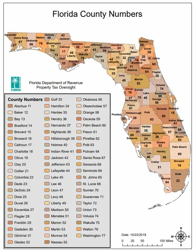
Q. Where is Polk County, Florida, on the Map?
Polk County, Florida, is located in the Central West District. It is at the heart of the peninsula extending into the gulf. Polk is one of the bigger counties in Florida by land area, with Lakeland as its largest city. It sits between Orlando and Tampa County, which makes it a central hub for both.
Q. How Many Counties Does Florida Have?
67.
Watch the video on the longest continuous walk around the world