Maps of Albania
Location and Size of Albania
Albania is a small country in the southern part of Europe. It sits along the Balkan Peninsula and has a coastline on the Adriatic Sea and the Ionian Sea. Because it touches two seas, Albania has many beaches and clear blue water. The country covers about 28,748 square kilometers. This makes it smaller than many European countries, but it is still full of beautiful places. The capital city is Tirana, which is in the central part of the country. Albania features mountains, lakes, and valleys that make it a great place to explore.
Geography of Albania.
The geography of Albania changes a lot from place to place. The western side of the country has flat land and long beaches. Many tourists visit these coastal areas because the weather is warm and sunny. When you travel toward the middle and east of the country, the land becomes more hilly. Tall mountains covered with forests and rocky cliffs rise in the eastern part. Albania also has many green fields where people grow crops and keep animals. The country gets warm summers and cool winters. Snow falls mainly in the mountain areas. In spring and autumn, the weather is pleasant, and many plants grow well.
Rivers and Mountains on Maps of Albania
Albania has many rivers that help the land stay fertile. One of the longest rivers is the Drin River. It runs across the northern part of the country and is important for farming and electricity. The Vjosa River is another well-known river. It flows with few dams, which makes it special in Europe. Albania also has large lakes. Lake Shkodra, near the border with Montenegro, is the biggest lake in the country.
The mountains in Albania are tall and rugged. The Albanian Alps in the north are known for sharp peaks and deep valleys. One of the highest mountains is Mount Korab, which reaches 2,764 meters. Many hikers visit these mountains to enjoy the clean air and amazing views. The mountains also have animals like deer, bears, and eagles.
Population
Albania has a population of about 2.7 million people. Most of the population lives in cities and towns where there are schools, markets, and jobs. Tirana is the largest city and has colorful buildings, busy streets, and many cafés. Other key cities are Durres, close to the sea, and Shkodra, famous for its rich history and culture. Many families in Albania have strong traditions and enjoy spending time together.
Demographics
The people of Albania belong mostly to one main ethnic group called Albanians. They share the same history and cultural practices. There are also small groups of Greeks, Roma, and others. The main language spoken in the country is Albanian. It is one of the oldest languages in Europe. Most people follow Islam or Christianity, and they live together peacefully. Many Albanian families enjoy music, dance, and storytelling. Folk dances, colorful costumes, and traditional songs are key parts of their culture.
Economy
The economy of Albania is growing slowly each year. Many people work in farming. Farmers grow olives, grapes, wheat, fruits, and vegetables. Albania is known for its olive oil and fresh produce. Fishing is important in coastal areas because the sea is full of fish. The country also has minerals like chromium, copper, and iron. Tourism has become one of the biggest parts of the economy. Many visitors travel to Albania to enjoy beaches, mountains, and old cities. Small businesses, shops, and hotels also help the economy grow. Some people work in building, transportation, and crafts.
Trade
Albania trades many goods with other countries. It sells items like minerals, metals, olive oil, fruits, and clothing. It buys machines, fuel, medicines, and other products that it needs. Albania trades often with Italy, Greece, Germany, and Turkey. The ports along the Adriatic Sea help ships move goods in and out of the country. Trade is key for Albania as the country grows. It helps connect Albania to the world.
Neighbouring Countries
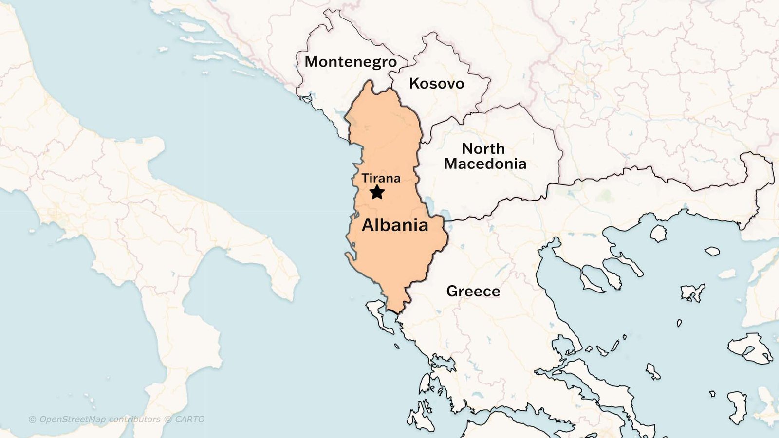
Albania shares borders with four countries. To the northwest is Montenegro, and to the northeast is Kosovo. North Macedonia is to the east, and Greece is to the south. Albania also has long coastlines along the Adriatic Sea to the west and the Ionian Sea to the southwest. These neighbors help Albania with trade, travel, and cultural exchange. Many people cross the borders for work, business, and family visits.
International Relations
Albania works closely with many countries to build strong friendships. It is a member of the United Nations and the North Atlantic Treaty Organization. Albania is also working to join the European Union. The country is upgrading its laws, schools, and services. It aims to meet European standards. Albania joins meetings and agreements to boost safety, education, trade, and peace. The country hopes to continue improving its relationships with the rest of the world.
Tourist Spot
Albania has many beautiful places that attract tourists. The city of Berat is known as the city of a thousand windows because of its old houses built on the hillside. Gjirokastër is another historic city with stone buildings and a large castle. The Albanian Riviera along the Ionian Sea has some of the most stunning beaches in Europe. Places like Ksamil and Himarë are famous for bright blue water and soft sand. Lake Ohrid in the east is very deep and full of fish. Theth National Park in the north is great for hiking. You can explore waterfalls, forests, and mountain villages there. Albania’s mix of nature and history makes it a popular place to visit.
Read more about History of Israel Palestine conflict, explained
Interesting Facts
• Albania has its own special language called Albanian.
• The capital city, Tirana, is full of bright, colorful buildings.
• The country has both beaches and tall mountains.
• Mount Korab is the highest point in Albania.
• Albanians greet each other with warm hospitality.
• Many families make homemade olive oil.
• Albania has one of the oldest lakes in Europe, called Lake Ohrid.
Watch Albania Geography on YouTube