Introduction to Resources and Development
Hello friends, in this blog post, we will discuss the first chapter of Class 10th Geography: Resources and Development Class 10 Notes
You might be wondering, what are resources? What does the term “resources” mean?
Defining Resources
Anything available in our nature that fulfills our needs is called a resource. However, there are certain conditions: the item must be technologically accessible, economically feasible, meaning it should provide economic profit, and culturally acceptable, ensuring it causes no harm to people. If an item satisfies these three conditions, it is termed a resource.
So, resources mean everything available in our environment that can be used to satisfy our needs, provided it is technologically accessible, economically feasible, and culturally acceptable.
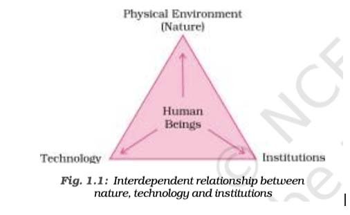
Understanding the Resource Diagram
Now, take a close look at this diagram. It shows the relationship between technology, nature, and institutions, highlighting how these three are interdependent.
Humans, being resourceful, use technology to interact with natural elements, often depleting them, and develop resources that contribute to the country’s or their own economic development.
Classification of Resources
Let’s now explore the classification of resources. Resources are divided into four parts:
- On the basis of origin: Biotic and abiotic resources.
- On the basis of exhaustibility: Renewable and non-renewable resources.
- On the basis of ownership: Individual, community, national, and international resources.
- On the basis of status of development: Potential, developed, stock, and reserve resources.
Let’s dive into these classifications in detail.
Resources Based on Origin
The first classification of resources is based on origin, dividing them into two types: biotic and abiotic resources.
Before understanding biotic resources, let’s learn about the biosphere. The biosphere is the zone where all zones merge. Biotic resources come from the biosphere and have life, such as human beings, flora and fauna, fisheries, livestock, etc. So, biotic resources are those obtained from the biosphere and have life.
Now, what are abiotic resources? Abiotic resources are made from non-living things, meaning they lack life. For example, rocks and metals. So, abiotic resources are all those things composed of non-living materials.
Resources Based on Exhaustibility
The second classification is based on exhaustibility, dividing resources into renewable and non-renewable resources.
Renewable Resources: These are resources we can renew or reproduce using physical, chemical, or mechanical processes. Examples include solar and wind energy, water, forests, and wildlife. These resources can be renewed or reproduced, hence they are called renewable or replenishable resources. Renewable resources can further be divided into continuous or flow resources—refer to the diagram.
Non-Renewable Resources: These resources take a very long geological time to renew. (Look at that, Binod!) They cannot be easily renewed. Examples include minerals and fossil fuels. Non-renewable resources, once exhausted, cannot be immediately renewed, as their formation takes millions of years.
Resources Based on Ownership
The third classification is based on ownership, dividing resources into four types: individual, community, national, and international resources.
- Individual Resources: These are resources privately purchased by a person, becoming their personal property. Examples include plots, houses, plantations, cars, books, and phones. So, individual resources are those owned privately by individuals.
- Community-Owned Resources: These are resources accessible to all members of a community, regardless of caste, creed, race, or gender. Examples include village ponds, public parks, picnic spots, and playgrounds. So, community-owned resources are those accessible to everyone in the community.
- National Resources: Technically, every resource found in a country is a national resource. The government has the legal authority to acquire any resource for public welfare, providing fair compensation. Examples include minerals, water resources, forests, and wildlife. Even the area from the coastline to 12 nautical miles (22.2 km) is part of national resources. So, all resources belonging to the nation are called national resources.
- International Resources: These are resources not controlled by any single country, and no one country can exclusively use them. They are regulated by international institutions. For example, the ocean water beyond 200 nautical miles, known as the open sea, is an international resource. Countries need permission from international institutions to use these. So, international resources are those not owned by any specific country and are regulated by international institutions.
Resources Based on Status of Development
The fourth classification is based on the status of development, dividing resources into four types: potential, developed, stock, and reserve resources.
- Potential Resources: For example, in Rajasthan, there’s abundant sunlight, so we can generate solar energy. In Gujarat, strong winds allow us to use wind turbines to harness wind energy. These resources are available in nature, but we aren’t utilizing them. Examples include Rajasthan’s sunlight and Gujarat’s wind.
- Developed Resources: These are resources whose quality and quantity are known, and we are actively using them. Examples include coal, petroleum, and iron. So, developed resources are those surveyed, with their quality and quantity determined for utilization.
- Stock Resources: These have the potential to meet human needs, but we lack the technology to access them. For example, water is a compound of two inflammable gases, H2 (hydrogen, a fuel) and O2 (oxygen, essential for life). Both are useful, but we cannot extract them separately from water. So, stock resources are materials with potential to satisfy human needs, but humans lack the technology to access them.
- Reserve Resources: These are resources we have the technology to use but choose not to, reserving them for future needs. For example, river water can be used for hydroelectric power, but we limit its use to ensure availability for the future. Examples include water in dams and forests. So, reserve resources are those that can be utilized with existing technology but are kept for future requirements.
Development of Resources
We all know how essential resources are. They are a free gift from nature. However, humans have used these resources indiscriminately, leading to numerous problems today and creating challenges for future generations. Let’s explore the problems caused by this misuse.
Problems from Indiscriminate Use
We face three main problems:
- Overuse by the Greedy: A few greedy individuals have overused resources for personal gain, leading to their depletion.
- Unequal Distribution: Resources are concentrated among a few, dividing society into haves and have-nots—rich and poor. Those with more resources grow richer, while those with less become poorer, splitting society further.
- Economic and Environmental Crises: Overexploitation has caused issues like global warming, ozone layer depletion, environmental pollution, and land degradation.
Sustainable Development
To ensure resources last for future generations, we need sustainable development. This means using resources in a way that doesn’t harm the environment and ensures availability for future generations.
The idea of sustainable development emerged from the 1992 Rio de Janeiro Earth Summit, the world’s first Earth Summit, held in Brazil. Over 100 countries participated to discuss protecting the environment and finding solutions to environmental problems for socioeconomic development. The outcomes included:
- Global Forest Principles: All countries agreed to use and protect forests sustainably.
- Agenda 21: A declaration outlining a blueprint to address human-created environmental problems and protect the environment.
Resource Planning in India
Resource planning involves using resources effectively. For example, Jharkhand and Chhattisgarh have abundant minerals and coal, Rajasthan has solar and wind energy but lacks water, while Arunachal Pradesh has water but lacks infrastructure. Resources are unevenly distributed, making planning essential for balanced development across the country.
Resource planning in India has three steps:
- Identification and Inventory: Conducting surveys, mapping, checking quality and quantity, and creating a resource list.
- Evolving a Planning Structure: Researching resource locations, planning extraction technologies, required skills, and institutional setups.
- Matching with National Plans: Ensuring resource plans align with national development goals to benefit the country without causing harm.
Resources are vital, but so is technology. Without technology, we cannot extract or develop resources effectively. Before 1947, British rulers exploited India’s resources, known as the “golden bird” for its wealth. This exploitation led to resource scarcity today, making conservation crucial. As Gandhi said, “There are enough resources for everyone’s needs, but not for anyone’s greed.”
Land Resources
Land is a critical resource. We depend on it for agriculture, housing, wildlife, and forests. In India, 43% of land is plains, 30% is mountainous, and 20% is plateaus, showing diverse relief features.
Land Utilization
Land is used for:
- Forests: Areas with dense jungles.
- Non-Cultivable Land: Barren, wasteland, or land used for buildings, roads, and factories.
- Other Uncultivated Land: Grazing land, land with miscellaneous trees, or culturable wasteland (land not cultivated for over 5 years but suitable for farming).
- Fallow Land: Current fallow (not cultivated for 1 year) and other fallow (not cultivated for 1–5 years).
- Net Sown Area: Land cultivated at least once a year, also called gross cropped area.
Land Use Pattern in India
Refer to the diagram for data on land use from 1960–61 and 2014. India’s total geographical area is 3.28 million square kilometers, but we have data for only 93% of it. The remaining 7%—disputed areas like parts of Jammu and Kashmir and Assam—lacks proper surveys. The 93% is well-utilized with available data.
The net sown area varies by state. Punjab and Haryana have over 80% net sown area, while Arunachal Pradesh, Manipur, Mizoram, and Andaman Nicobar Islands have less than 10%. So, the net sown area varies greatly across states.
Forest Area
From 1960–61 (18.11%) to 2014–15 (23.3%), forest cover has increased, but it’s still below the National Forest Policy’s recommended 33%. Forests are crucial for ecological balance and supporting communities dependent on them, making afforestation essential.
Land Degradation and Conservation
Over time, land is degrading. Land, used by past and future generations, meets 95% of our needs (food, shelter, clothing). In India, about 130 million hectares are degraded: 28% is forest-degraded, 56% is water-eroded, and the rest is affected by saline and alkaline deposits.
Causes of Degradation:
- Deforestation: Excessive tree cutting for mining in Jharkhand, Chhattisgarh, Madhya Pradesh, and Odisha.
- Overgrazing: Sheep and goats damage the topsoil in Gujarat, Rajasthan, Madhya Pradesh, and Maharashtra.
- Over-Irrigation: Excess water makes land saline or alkaline in Punjab, Haryana, and western Uttar Pradesh.
- Cement Industries: Dust from cement plants degrades nearby land.
- Industrial Waste: Direct disposal of industrial waste causes land and water pollution.
Conservation Measures:
- Afforestation: Planting trees.
- Managing Grazing Lands: Proper management of grazing areas.
- Proper Irrigation: Reducing water wastage.
- Controlling Mining: Regulating mining activities.
- Proper Waste Disposal: Managing industrial effluents.
Soil as a Resource
Soil is the most important renewable natural resource, essential for plant growth and supporting living organisms. It takes millions of years to form a few centimetres of soil. Soil varies by formation, color, thickness, texture, age, and chemical/physical properties. India classifies soils into alluvial, black, red and yellow, laterite, arid, and forest soils.
- Alluvial Soil: The most fertile soil, found in northern and coastal plains, deposited by rivers like the Indus, Ganga, Brahmaputra, Mahanadi, Godavari, Krishna, and Kaveri. It’s divided into old (Bangar) and new (Khadar) alluvial soil, containing sand, silt, and clay. Rich in potash, phosphoric acid, and lime, it supports sugarcane, paddy, wheat, and other crops, enabling dense cultivation and population.
- Black Soil: Also called regur or black cotton soil, ideal for cotton, found in Maharashtra, Saurashtra, Malwa, Madhya Pradesh, and Chhattisgarh. It retains moisture and contains calcium carbonate, magnesium, potash, and lime.
- Red and Yellow Soil: Formed from crystalline igneous rocks in low-rainfall areas, found in Odisha, Chhattisgarh, and parts of the middle Ganga plain. Its red color comes from iron, turning yellow when hydrated.
- Laterite Soil: Found in high-temperature, high-rainfall areas like Karnataka, Kerala, Tamil Nadu, Madhya Pradesh, Odisha, and Assam. Less fertile due to destroyed microorganisms, it’s used for cultivation with fertilizers and supports tea, coffee, and cashew crops.
- Arid Soil: Found in low-rainfall areas like Rajasthan, with a red-to-brown color and sandy, saline texture. Low in humus and moisture, it can be cultivated with proper irrigation.
- Forest Soil: Found in mountainous Himalayan regions with sufficient rainfall. It’s loamy and silty in valleys, coarse on slopes, less fertile on upper slopes due to acidic conditions, and more fertile lower down. Suitable for coffee and tea.
Soil Erosion and Conservation
Soil Erosion: The removal of the topmost fertile soil layer by wind or fast-running water. Types include:
- Gullies: Water creates canal-like flows, washing away fertile elements. In the Chambal region, these are called ravines.
- Sheet Erosion: Water washes away the topsoil layer.
- Wind Erosion: Wind blows away the topsoil.
Soil Conservation Methods:
- Contour Ploughing: Farming along contour lines to slow water flow.
- Terrace Farming: Creating steps on hills to restrict erosion, common in the western and central Himalayas.
- Strip Cropping: Dividing large fields into grass strips to reduce wind force.
- Shelter Belts: Planting rows of trees to slow winds and protect crops.
Conclusion
I hope you found this blog post informative. Stay tuned for more insightful content!
Read more: Geography of the Rocky Mountains