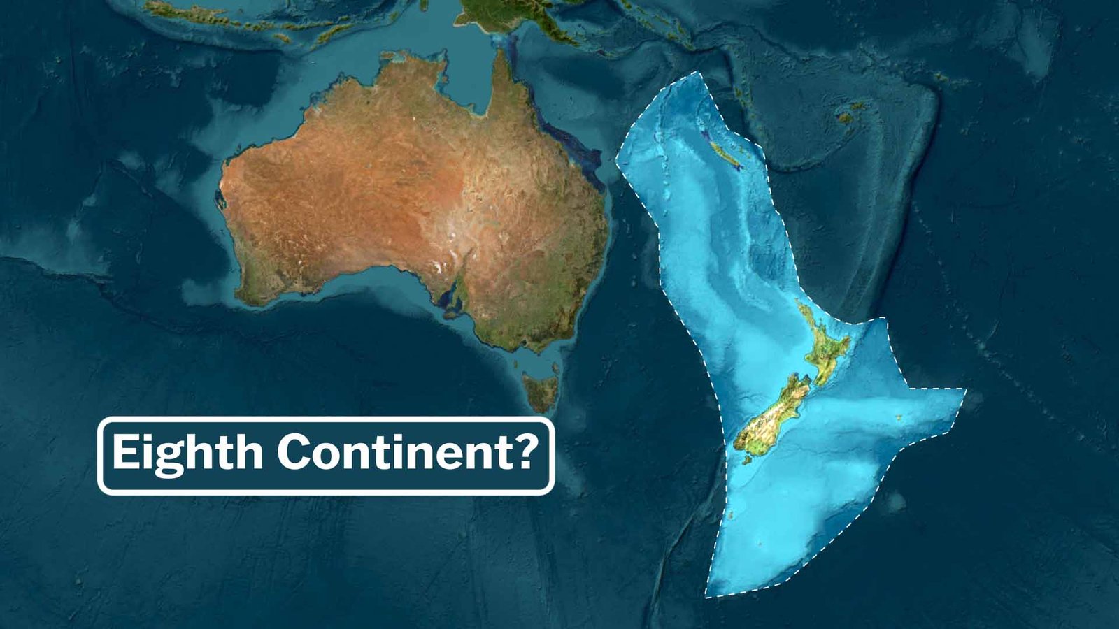
What if I told you that Earth has an eighth continent, far away from everything else—and most of it is hidden beneath the waves?
You might picture the familiar seven continents we learned about in school: Africa, Antarctica, Asia, Australia, Europe, North America, and South America. But in recent years, geologists have made a compelling case for an eighth: Zealandia, also known as Te Riu-a-Māui in the Māori language. This vast, mostly submerged landmass has been hiding in plain sight for centuries, and its formal recognition as a continent in 2017 sent shockwaves through the scientific community.
The Origins of the Idea
The story begins long before modern science. In 1895, a geologist first hinted at something unusual about the region around New Zealand. But the concept truly took shape in 1995 when American oceanographer Bruce Luyendyk proposed the name “Zealandia” based on geological anomalies observed in the southwest Pacific.
It wasn’t until 2017 that a team of geologists—primarily from New Zealand, New Caledonia, and Australia—published a landmark paper in the journal GSA Today. They argued that Zealandia meets the criteria for a full continent: it’s a large, coherent piece of continental crust that’s geologically distinct, elevated relative to the surrounding ocean floor, and has a thick crust with continental rocks like granite and greywacke.
Since then, research has continued. By 2023, scientists completed the first full geological mapping of Zealandia, making it the first continent ever to have its entire geology, volcanoes, and sedimentary basins charted to its underwater edges. Recent reviews (as late as 2025) have refined our understanding of its tectonic history and origins.
What Exactly Is Zealandia?
Zealandia is a submerged continent—a long, narrow microcontinent (though many now classify it as a full continent) stretching across the South Pacific. Its total area is approximately 4.9 million square kilometres (about 1.9 million square miles)—roughly half the size of Australia, larger than the Indian subcontinent, and far bigger than the Arabian Peninsula (the world’s largest peninsula).
Here’s the mind-blowing part: 94–95% of Zealandia lies beneath the ocean, submerged at depths often exceeding 1 kilometer. Only about 6% pokes above sea level, forming:
- The islands of New Zealand (North and South Islands, plus smaller ones),
- New Caledonia (a French territory),
- Lord Howe Island (Australian territory), and
- Scattered features like Ball’s Pyramid.
This makes Zealandia the smallest, thinnest, youngest, and most submerged of Earth’s continents.
A Geological Backstory: Breaking Away from Gondwana
Zealandia’s history ties back to the ancient supercontinent Gondwana. Around 100–85 million years ago (during the time of dinosaurs), it began rifting away from what is now Antarctica. It then separated from Australia around 80–55 million years ago as the Tasman Sea opened up.
Over time, Zealandia thinned dramatically and subsided due to tectonic stretching and cooling, sinking gradually until much of it drowned by about 23–25 million years ago. Unlike Australia or Antarctica, which remained mostly above water, Zealandia largely disappeared beneath the Pacific.
Recent studies suggest parts of Zealandia are even older than previously thought—over a billion years in some areas—and it features ancient volcanic regions (one lava field alone covers an area the size of New Zealand itself), seismic activity along plate boundaries, and unique sedimentary basins.
Why Does It Count as a Continent?
Continents aren’t just defined by what’s above water. Geologists use criteria like:
- Large area and coherent structure,
- Continental crust (thicker and less dense than oceanic crust),
- Geological distinction from the surrounding areas,
- Isolation from other major landmasses.
Zealandia checks these boxes. It’s not a mere microcontinent or fragment—it’s a distinct, continent-sized slab of crust on its own trajectory since breaking from Gondwana.
(Note: There’s no official “continent approval” body, so recognition comes from widespread scientific acceptance and citation. Many experts now refer to it as Earth’s eighth continent.)
Why It Matters—and Why It’s Still “Hidden”
Zealandia challenges how we think about continents and land. It reminds us that our planet’s surface is dynamic, with most of Earth’s crust (especially oceanic) still underexplored—we know more about the Moon’s surface than the deep ocean floor in some places!
This sunken landmass holds clues to ancient climates, ecosystems (fossils suggest it once had land bridges for plants and animals), plate tectonics, and even hazards like earthquakes and volcanoes in the region today.
As mapping advances and research continues (including recent 2025 reviews of its tectonics), Zealandia is no longer “lost”—it’s a recognised part of Earth’s story.
So next time you look at a map of the Pacific, remember: beneath those blue waters lies a hidden continent, a geological secret that rewrites what we thought we knew about our world.
What do you think—does Zealandia deserve to be called the eighth continent? Or should we stick to the traditional seven? Drop your thoughts below!
Also read: History of Ancient India